Saturday, June 30, 2012

Crossing Washington On The JWPT - Day 2

The plan for Day 2 was to ride another 50 miles, from about mile 65 on the map below to about mile 115. What distinguished this day's route was its remoteness - no towns, no known water sources . . . nothing but harsh, rocky landscape until maybe, if we were able to log the miles, we would reach the town of Lind, towards day's end. If that were to happen, there was a bar and grill there, at which a beer and a burger might be available. Never in the history of the world has a more worthy goal existed. After dinner, we would pedal 10 or so miles out past Lind and find our spot for the night.


What actually happened was that despite a tremendous amount of work, we pedaled a mere 35 total miles and covered just 22 miles of the actual JWPT.  The green line running from east-to-west on the map below is the JWPT and the orange path over it is our 22 miles of actual progress. The orange off-trail loop to the south is a detour we took around a section of the trail known as Cow Creek. (The vertical green line, BTW, is the Columbia Plateau Trail, another abandoned railbed that subtly beckons me and will probably host another of my excursions at some point.)

Here's how the day went down . . .

The previous night we'd been in a bit of a hurry to find a place to pitch camp, because it looked as if a storm was rolling in, and pretty quickly. The storm never really materialized, but it was obvious that something was changing, weather-wise. Clear skies greeted us on the morning of Day 2, along with a breeze.   It was coming at us from the west, but hey, who doesn't love a breeze? We were one with nature! Embrace the elements! What's not to love???

That trestle in the distance is the Columbia Plateau Trail.

For me, a significant part of the allure of riding the abandoned Milwaukee Road is at least a mild fascination with railroads in general.  One of the things that was a surprise to me is how intertwined the dead and active rail lines were out here in no-man's land. On multiple occasions while riding our ghost rails, we'd be watching and listening to living trains on one side or the other. It was a pretty badass sensation.


The pictures I've posted so far don't really do justice to the surface of the eastern-portion of the JWPT, but we'd been getting bounced and shaken around pretty hard over the last day-and-a-half and now it was getting serious. It was also starting to feel pretty damned forsaken. And did I mention that the breeze had turned into what one might call wind.


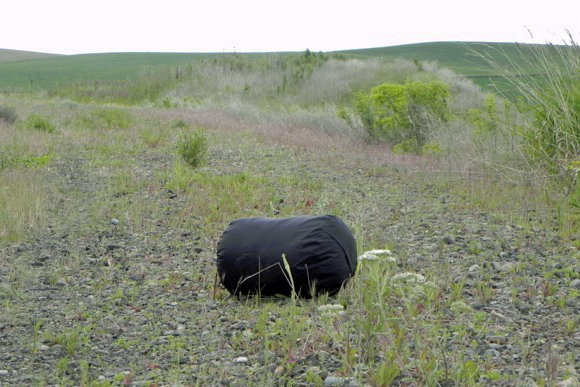
As if on cue, images of death began to appear. This poor fella was lying right in the middle of the trail. A not-so-subtle reminder to us city-dwelling would-be adventurers that this wasn't a game. He was sustaining a whole eco-system of flies and maggots, so his death was not in vain. And in some way, it was a consolation to know that there was no longer the possibility of ending up on the business end of those gnarly fangs.


. . . or have to worry about a shredding from those claws. Which had been widely separated from the body. No man's land, man. I'm here to tell ya.


I'm a hundred percent sure I would never have noticed this if we hadn't chanced to take a rest stop right next to it. Even then, I almost didn't. It's a deliberately-formed pile of rocks with some fading fluorescent orange spray paint scrawling on the side.  I didn't capture the text very well with this shot . . .


. . . but if I Photoshop the light way down it's a little more visible. If you still can't quite make out the text, it's 'RIP'. So yeah, a grave, right off the side of the trail. Seriously eerie. I spent a long time while there and as we pedaled on down the trail, and even now, thinking about it. Somebody went to a hell of a lot of effort to bury something there, in order to protect it's body/carcass from becoming a free-for-all to the animals in the vicinity. It wasn't big enough to be the grave of a horse. And the only other creatures I can think of that would fit this amount of effort and size of grave would be a person or a large dog. And while it's possible, it's hard for me to think about a person being buried this way, in this day and age. Not that it would be particularly bad, but just that I think that it's unlikely. Maybe though. I guess I choose to believe it's a dog, whose best human friend wanted him to have a place where he could look out over the fields where he once helped tend to the cattle. It's a more convenient and comfortable conclusion for me that way.


In direct contrast to this somberness, the beauty of the wildflowers couldn't be contained.


Meanwhile, the road seemed to be getting rougher. And the wind was getting windier.


There's a section here that isn't supported by photos. I'm having a hard time believing it myself, as I've become such a PITA shutterbug. But I guess things were getting kind of serious in terms of our situation and I must have been pretty occupied by it. So I'll just describe this next part then, until the pictures pick up again.

We were getting kind of, but not anywhere near desperately, low on water. And we were approaching a section of the trail known as Cow Creek. Cow Creek is marked on the maps that the state sent me with my permits as 'impassible'. I'd done the recon on most sections of the eastern portion that I thought I needed to know about to make the trip a success, but somehow Cow Creek had eluded my consciousness, slipped off my radar. Eric, however, had ridden through it in August of last year, from west to east, and was telling us that it was quite a bushwhack. He suspected that in June, it might be pretty swampy, and therefore even more work. I've been embarrassed to tell you this until now, but my bike and gear weighed 100 lbs (yes, I know it's obscene, but it's fact), and Scott was towing a trailer that was a bit of a challenge through the rough stuff, and Eric was thinking that the decision to plow through Cow Creek may not be the best one. Scott and I were listening.

We were at the crossroads of our decision to continue on the trail or bail out and try to detour on roads at the town (?) of Marengo (nothing there except a grain elevator . . . no houses, no faucet, we looked). It's a surreal memory for me though, because at Morengo, the JWPT and the active Union Pacific line converge and the train that you saw a few pictures back was stopped there, presumably to wait for another train down the line to get off on a siding, and it was just sitting there, watching us make our decision. It was getting seriously windy at this point, so it took some commitment to fight our way down a path we weren't sure of, but we decided to get off the trail and try a road that showed promise. A mile or so down this road and we realized it was gonna dead end. Damnit.  Back to Morengo.

Another road led out of "town". To our credit, we were ever the optimists and followed it. Was it ever a beautiful, smooth road. But was it ever looking more and more like it was turning from a somewhat public road into a somewhat private road that led into a ranch and faded into a field. Maybe it went on and remained a road that would lead us on our detour, or maybe not, which meant more backtracking. 'No Trespassing' signs abounded. Our water was getting pretty low. Lovely. We stopped there for a long time and deliberated over our options. The two different maps I had didn't show enough detail to help. Neither did my GPS. Risk is not a bad thing, but going forward seemed to contain just a bit too much of a not bad thing.

We could always get back on the JWPT and take our chances at bushwhacking our way through Cow Creek, but it had gotten windy as hell and we'd expended a lot of energy and time on trying to figure out a detour and did I mention our water was getting low. What our maps did show was that the active Union Pacific line would lead us to roads we could identify on our maps and which would lead us back to intersection with the trail, at the tiny town of Ralston, on the other side of Cow Creek.

With 20-20 hindsight, I'm not sure it was the right decision. "Riding the rails" seems like a swell idea, until you actually try it. It's brutal, and after a few hundred yards of experimenting with riding down the center, riding to the right, riding to the left, we all pretty much resigned ourselves to walking our bikes down the tracks. For 3-1/2 miles. Longest damn walk of my life.

And I'm sure that there are many places in the country where there is no such thing as shade, but for us Spokane-dwellers, it's a given and suddenly we were in an environment where there was none to be found. Oh wait, sorry, there was an occasional rock cut where you could lean against one hot wall and get part of your body out of the sun. Did I mention that it was one windy bastard of a day and that my water supply was almost exhausted, and that I was so freaking elated that I had chosen to spend my vacation this way.


Our live rail journey finally, mercifully, ended, only to dump us onto a paved road that would climb for the next 2-1/2 miles, straight into the bitch of a windstorm that had developed. No one in the history of the universe has ever ridden a bike more slowly than I rode my bike up that hill. Flipping you the bird, mother nature.

Eric was leading the way, and then Scott, with me and my hundred pound turd bringing up the rear.  At the top of the hill, was the only tree within a thousand mile radius.


Not a word was spoken. Instinct took over. Eric pulled off. Then Scott. I was only too happy to follow suit. It was a spontaneous kindergarten-style group nap in the dirt under that tree, with the wind beating the hell out of us all the while. We were burnt toast.


The realization that we weren't gonna reach our planned destination had set in hours ago; we were more focused on figuring out a way to use what little energy we had left to get to a place where we could hunker down. Fortunately, Eric had toured through these parts at some point and remembered that there was a small memorial park in the tiny town of Ralston. Our new destination then, about 5 or 6 miles away. But Eric and I had fully depleted our water supplies - bone dry. And then miraculously Scott pulled out a full half-gallon bottle of good, clean, energizing Spokane water that he'd been hauling in his BoB. He filled our bottles and all manner of hope was restored.

It seemed like it took one hell of a long time to get there and I guess I will never forget the last stretch, which was several hundred yards on a flat smooth dirt road. Eric was in front of me and I would watch the gusts of wind and dust twist and surge down the road towards him and then hit him and almost knock him off his bike, and then continue down the road toward me, where they would force me sideways to keep my balance. I vowed to keep my speed at 5 mph, but lost my battle of wills with the wind when my speedometer showed 4.8.

When we finally arrived, it was such an oasis. A mirage, maybe  There is no such thing as grass in these parts, no such thing as trees that break the wind.


And certainly no such thing as cold, clear water that runs from the ground!


There was no euphoria, no celebration of any kind that we had made it. We just existed there. Fried eggs were we. Mostly feeling like total crap and  too wasted to eat, I was just about trying to rehydrate and recuperate. We were zombies, just doing what we had to do to ride out the windstorm. Camping there was probably not permitted, but we had no option and we were so grateful for this place. If anyone had confronted us, we'd have just told them that we didn't plan to be there but that we honestly didn't have any other choice, and hoped for their understanding.
 

Despite everything that had happened during Day 2, or maybe because of it, what was most profound to me was that we were taking refuge in a park that existed due to the ultimate sacrifice of some guys who had been raised in and around this tiny town. As I read the memorials, nothing that we had done that day seemed very hard, or worthy of note even, and at once I felt very honored and privileged and grateful to be staying in this place.


Day 2 Ride Stats
35 miles
6:14 saddle time
5.5 mph avg
16.1 mph max
105 total trip miles

Wednesday, June 27, 2012

Crossing Washington On The JWPT - Day 1

Day 1 was the first bona fide day of touring and the plan was to ride about 50 miles, from about mile 15 on the map below to about mile 65. The only access to any kind of services (i.e. food, water) would be in Rosalia, which was about 10 miles in.  The big event for the day would be passing by Rock Lake, which is the long, skinny body of water sitting under the 50 mile marker on the map.

For the appetizer, we ordered up more classic Palouse farm country. I knew however, that we would be trying something different for the main course.


One of the brazillion deer we saw.

Wha??

One of the brazillion rock cuts we pedalled through. They never got old though.


As we were just about to cross the rad trestles leading into Rosalia, Eric noticed that the filling had squished out of Scott's sleeping burrito. See the blue rolled-up pad and the sleeping bag inside it on Eric's bike? That's exactly the way Scott's was supposed to look, but all you can see is the pad.


Scott promptly dropped his trailer and set about the business of backtracking. A sleeping bag would be a tough item to replace in these parts, and an even tougher item to live without. Finding it was mighty important.


Meanwhile, Eric and I rode into Rosalia in search of breakfast. There were two choices: A coffee shop and The Fairlane. The coffee shop looked nice, if you were after coffee and pastries, but we needed something a bit more solid, hearty. The Fairlane looked like maybe the kind of place that could deliver. It's a real different place though.

The proprietor (who we didn't at that moment know was the proprietor) was out front smoking and there wasn't a soul inside. We struck up a light conversation, about the availability of coffee and some breakfast food, and of course about what the hell we were doing in Rosalia and where we were coming from and where we hoped to end up. And "man, those are some crazy tires. Never seen anything like 'em". If I had a quarter for every time someone said something about my tires on this trip, I could buy a motor home and be done with all this cycling nonsense.

The proprietor, as well as he establishment itself, are one-of-a-kind. He's a biker (the Orange County Chopper kind) and the place is totally multi-purpose - everything from cafe in the morning to bar and grill in the afternoon/evening. With a dance floor. And areas with big-screen TV's and sofa's. And parking space for his kickass custom chopper, which he told us he built himself. Everything there happens on Fairlane time and in the Fairlane way. Bottom line though, is that we got exactly what we were after.


While we were eating, a group of 10 or 12 bikers rolled up and the place started to coming to life and the beer started flowing. At 10:30 am. Righteous. More questions about what we were doing and why, and "hey man, check out those tires!" In general, once everyone kind of got their heads around what we were doing, they were full of support and encouragement. Or maybe that was just the beer talking. Whatever it was, it was good.


Meanwhile, after more than a few miles, Scott had tracked down his bag . . . it was right where he'd left it.

(Photo courtesy Scott)
Just outside of Rosalia, we bagged our first tunnel. It was kind of rinky-dink, a culvert affair, but definitely a tunnel, for damn sure. And therefore worthy of a mild celebration.

Tunnel power!!!  (Photo courtesy Scott)
Next stop on the westbound Milwaukee Road would be the town of Warden Malden (Sorry, Warden happens in a coupla days!). Houses and a post office and that's it. But we didn't even see them because the rail line was on the other side of a majorly big berm that separated it from town. What was interesting about Warden Malden though, was that it must have been quite a significant hub in railroad days. There were multiple concrete foundations next to the trail that would have supported water tanks for filling steam trains and probably coal hoppers and who knows what all else. And obvious sidings. There was also a cool old weathered building that looked liked it was probably a bunkhouse for crew or maybe even a station. Or both.


No water though, and we were getting pretty parched. Next stop was Pine City. Not even a post office there, just houses. We looked for someone, anyone, out in their yard whom we could ask if we could fill our bottles from their hose. Nobody around. But Pine City also has a grain elevator and the grain elevator has a spigot. We knocked on the door but nobody was home. We hoped it would be okay and then we just let it rip. Did I mention we were really thirsty on death's doorstep?


The portion of the trail approaching and passing through the Rock Lake area is hands down the most spectacular portion of the eastern section, scenery-wise. IMHO. I'll just shut up and let you enjoy the next few pictures.


Rock lake is an obvious product of the Missoula Floods, with its sheer basalt walls. The railroad is carved right into the side of one of those and as a result, there are a number of awesome tunnels and trestles. Not the wimpy kind, but the super real deal.


At the outlet of the second tunnel is a rockfall that is hardcore hike-a-bike, no two ways about it. Dump everything off your bike and carry it across and then come back for your bike kind of stuff. So rad.


Scott and Eric, admiring the view from WAY above the lake. Just over the cable guardrail is a tremendous drop . . . I don't know, 100 ft, 200 ft, whatever. Awe inspiring. The trestle itself is unimproved and pretty much just they way they left it. Part of why the eastern portion of the trail, despite its harshness, is so awesome . . . it's totally authentic.


What a cool old signal tower. But rusty and decrepit and a little scary, structurally. What kind of fool would climb up that rickety old ladder just to take a picture.


This kind, apparently.


The landscape had definitely changed over the course of the day.


Or in terms of my previous lame analogy, "Beef. It's what's for dinner."

Eric, aka "the cow whisperer", in action. One of the many other-worldly human/bovine interactions I witnessed.

Dessert.

It was a good day - we got our mileage in and it went pretty much according to plan. Little did we know, this would be our last "normal" day.

Day 1 Ride Stats
53 miles
6:34 saddle time
8.0 mph avg
21.6 mph max
71 total trip miles

Sunday, June 24, 2012

Crossing Washington On The JWPT - Prologue

My route across Washington on the John Wayne Pioneer Trail looks like this:


An interactive version is available here. Obviously, the route doesn't cross all of Washington; it finishes up at Puget Sound. A tacked on ferry ride and a crossing of the Olympic Peninsula out to the Pacific is awesome to think about, but wasn't in the cards for this trip. Another time, maybe.

The other thing worth noting about the route is that the JWPT trail only goes as far west as Rattlesnake Lake, on the western slope of the Cascades. From there, the route follows four other public access trails to the Sound. I'll talk about that section in detail in my Day 6 post.

I'd planned to take eight days plus a short beginning day that I called the "Prologue", to make the crossing. This was based on an expectation of a rough average of 50 miles a day and an average speed of 10 mph.  This meant 5 or 6 hours a day in the saddle, which should leave plenty of time for some R&R. The last thing I wanted this trip to be was a rush - I wanted time to really get into the experience and enjoy the surroundings. I wanted to take lots of pictures. And read a book. Oy, if I had known then what I know now.

In the spirit of getting immersed into the trip, the Prologue was all about cheating a bit, by escaping and getting onto the trail a little early. To avoid wasting any part of the first actual tour day on logistics or acclimation.  I worked until 2:00 on Prologue Friday and then bailed straight for home, where everything was packed and ready.  I loaded up and then Patty and I swung by Eric's house and loaded him and his gear and bee-lined for the Idaho border.  Our goal for the day was to get roughly 10 miles into the trip, which should place us right where we wanted to wake up on Saturday morning . . . smack in the middle of nowhere, WA.


We reached the border, loaded up and were ready to roll by about 5:30. Was I born to wear a cowboy hat or what?  (As usual, click any pic in the post to supersize.)


Under sunny skies and amidst the greenest fields ever, we basked in the euphoria of a tour just begun.


Five or six miles in, we reached Tekoa, where we joined up with Scott and re-joined up with Patty. We dined at their rad Bar and Grill, as per the master plan.

A bit about the cast of characters is in order, at this point. You already know me (left) too well. Eric (center) is a bike-circle friend who also turns 50 this year and who you may remember from the next-to-latest series of rack building classes. He's a seasoned tourer and pretty exceptional endurance athlete - he just ran a 3:17 in the Windermere Marathon, thereby qualifying him for the Boston Marathon. He loves this kind of stuff and originally planned to go halfway with me, but then later threw down for the whole enchilada. Scott (right) and I knew each other from the interwebs, but were just meeting for the first time in person. I was aware that he had a thing for rail trails and so I tossed out some trail-bait and he took it. He's a strong cyclist who nerds out on all manner of bike and camping gear, so he fit right in.


After a swell dinner complete with a coupla microbrews, I bid my lovely bride farewell and headed out on the open road with my tour mates. The massive trestle that spans Tekoa is closed and so we were forced to endure the horror of this detour.


We were in no big hurry to get anywhere, really, so once back on the trail we backtracked to the trestle, just 'cause.

Spiderman checks out the view from the deck. Neither of us particularly cared to join him.

We were treated to some damn fine scenery on the way out to our (as yet unknown) destination.


The trail was at times a bit challenging, possibly a portend to the events of the coming days, but we were too damn giddy to pay much attention.

Yes, it was in the middle of cow country and yes, it smelled as bad as it looks like it smelled.

We encountered the first of what would be many "routine" trestle detours on the eastern portion of the trail.  Most of these trestles spanned creeks or roads and the detours were a pretty minor inconvenience, although they did contribute in some way to slowing the overall pace. More on that later.


We found our spot for the night atop a nice vantage point next to a killer trestle and watched the sun go down and listened to packs of coyotes volley calls across the rolling hills. Life for the moment was very, very good.


Prologue Ride Stats
18 miles
2:02 saddle time
8.7 mph avg
28.2 mph max